|
Republic of Komi (11 rus), center — Syktyvkar
(formerly Ust'-Sysol'sk). A vast territory in the Nort-East of the European
part of Russian Federation, with the area greater than Germany but smaller than
France. The Eastern border of the Republic is the Ural Ridge, including
North Urals, Sub-Polar Urals (actually, the highest part of the Urals, up to 1895 meters
high — Mount Narodnaya), and Polar Urals. At the same time it is the geographic
border between Europe and Asia. The rest of the territory of the Republic of Komi is
occupied by Russian Plains: in the West — Mezen'-Vychegda plain and its hilly
Southern part, Severnye Uvaly; to the East of it, the Republic of Komi is crossed in the meridional
direction by the Timansky Kryazh — a mountain ridge very much worn out, up
to 500 meters high; between Timansky Kryazh and the Urals lies Pechora Depression.
Almost the whole area of Komi is covered by conifer woods; only the very North contains
tundra and forest-tundra. Principal rivers: Vychegda (right tributary of Severnaya Dvina)
with the left tributary Sysola and the right one Vym'; Mezen' and its right tributary Vashka;
Pechora with the right tributaries Usa and Shapkina. Minor parts of the Republic
belong to the basins of rivers Luza, Vyatka (both in the South-West), Kama (South) and Kara (North-East).
Official languages of the
Republic are Russian and Komi; 28% of the population are Komi. One more indigenous
group of population is Nenets; they are in a very small minority. According to the
official population count held in 2002, the total Komi population in Russia is 293
thousands, and the majority, 256 thousands, reside in the Republic of Komi. These numbers
only include so-called Zyryan Komi (Komi proper); they are ethnically and linguistically
different from Perm Komi, who formed the majority of the population in former Komi-Permyak
Autonomous District, recently abolished and made a part of Perm Region. A particular
ethnic group of Komi are Izhma Komi (about 15 thousands), who live mainly in Izhma district
and traditionally are reindeer breeders.
Komi language belongs to the Perm-Finnic group of Finno-Ugric family
of languages. This means it is as close to Estonian and Finnish as say English
to Spanish. The languages most closely related to Komi are Udmurt and Perm Komi.
Komi is written on the basis of Cyrillic script, a number of
newspapers are published. The situation is better than with other Finno-Ugric languages
in Russia (Mari, Udmurt, Karel, Moksha or Erzya), however, the number of
native speakers drops steadily (even though the share of Komi speakers in the Republic
increases, since the number of Russians drops even faster). Komi believers are
Christians, the conversion of Komi to Chrisitanity occurred not later than 16th century.
Finno-Ugric tribes populated the area of modern Western, Northern, and Central Russia since
prehistory. The archaeological sources of 12th—14th centuries,
discovered at the territory of the Republic, present evidences that
settlements of three ethnic unions existed at the time: Russians,
"Perm" (Finnic tribes, ancestors of modern Komi) and "Yugra" (Ugric tribes,
ancestors of modern Khanty and Mansi). In the literature, the Komi area is
sometimes associated with Bjarmaland, mentioned in Scandinavian sagas as
a place where the Vikings went to get fur. However, this association currently
does not enjoy any archaeological support and can not be considered seriously.
In 13th and 14th centuries the territory of the present-day Republic
of Komi, or, to be precise, Russian settlements there, were subordinate to
Novgorod,
then in 1478 Novgorod with all its lands was taken over by Moscow. In 1379, the seat of the Bishop
of Perm was introduced. The first Bishop was Stefan of Perm, who developed a special script
for Komi language (never used ever since) and translated the Bible to Komi. This means that the
christianization of Komi started earlier than of other Finno-Ugric peoples; it was also
the first one to be completed. In 1481, under Ivan the Third, a description (gazetteer) of Komi lands was
produced. Formally, it meant that these lands became a part of Muscovy. Russians
mostly settled along lower course of Vychegda River (the oldest preserved settlement in the
Republic is Ust'-Vym') and Luza River. In 16th century, they were the majority of the population in
these areas. In 1499, the expedition of Pyotr Ushaty, Semyon Kurbsky, and Vasily Brazhnik,
sent out by Ivan the Third to "pacify the Yugra", founded the fortress of Pustozersk in lower
course of Pechora River. The pacification was successfully performed, Pustozersk became an
administrative center and for a long time the most remote Russian settlement in the North-East,
and Komi lands thus lost the status of the border area. In 17th century, the modern territory of
the Republic was divided between three uezds (districts): Pustozersk,
Sol'vychegodsk, and Ust'-Vym', and after the governorships were introduced, it
was included into Vologda and Arkhangel'sk governorships. In 18th century, industry appears,
first the salt production and metallurgy, later — leather production and
extraction of tar. In the second half of 19th century, steam ships started to run
on the rivers Vychegda and Pechora. The October revolution in 1917 was followed by
two years of civil war, but already in 1921 Komi autonomous region was formed, with the center
in Ust'-Sysol'sk, and divided into Sysola, Ust'-Kulom, Ust'-Vym' and Izhma-Pechora districts.
In 1929 the autonomous region was included to the Northern Territory, governed from
Arkhangel'sk; in 1930, it was renamed to Komi Autonomous Republic and taken out from the
Territory; from 1991 — Republic of Komi. In the beginning of 1920s the overwhelming
majority of the population of the autonomous region still lived in the South-West, mainly
along the lower course of Vychegda River and its tributaries, Mezen' River, and lower course of Pechora River.
Everything changed dramatically in 1930s: Stalin's version of industrialization required rapid
development of the industry
branches able to produce an immediate effect — for Komi, extraction of raw materials.
It also required a large amount of unpaid workers. The extraction of Ukhta oil and
Vorkuta coal started, along with the production of wood almost everywhere in the Republic.
Towns on the permafrost and simply in the middle of the wood proliferated. In 1937, the
construction of the railroad between Kotlas and Vorkuta began; it was open for traffic in 1941.
All these industrial developments were mainly created by the prisoners of the concentration
("labor") camps: Sevlag ("Lag" is an abbreviation from "lager" — a camp; the administration
located in Syktyvkar), UkhtaPechorlag (Chib'yu, later Ukhta), Minlag (Inta), Sevpechlag (Abez'),
and Vorkutlag (Vorkuta) are just the most infamous ones. We do not really know how many prisoners
were ever sent to the concentration camps in Republic of Komi, but this number must be above a million.
We also do not know how many of them died or were eventually executed. In 1990s, the coal mining
became unprofitable, wood transportation in many places was unprofitable, too, many mines
closed, and it is not surprising that Republic of Komi is by a wide margin a leader in a number of
existing ghost towns. Heavy industry, except for mining and oiling, was never created, and one can
only hope that the republic will manage to realize a huge potential for tourism. In 1985,
virgin Komi forests were included
into UNESCO World Heritage list.
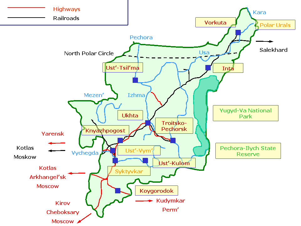
The principal transport line of Republic of Komi is the railway Kotlas - Vorkuta - Labytnangi,
with the side branches to Syktyvkar, Troitsko-Pechorsk, and Usinsk. Most of the roads can only be used in
Winter; only a minor amount are paved. The principal year-round highways are "Vyatka" Cheboksary - Kirov -
Syktyvkar and the newly built road Kotlas - Syktyvkar. To the North of Ukhta and Vuktyl, the connected
year-round road network does not exist. Passenger and cargo river navigation exists on Vychegda and Pechora.
|
|
1
|
Inta. From 1931, settlement around a concentration camp,
first for oil production, later for coal mining. A town from 1954. Inta has a dubious distinction
of one of the very few (if not the only one) towns developed from a concentration camp.
- The town center is built in one style, all buildings are of the same color —
yellow brickstone with a typical golden hue.
- Interesting area of wooden houses along Ulitsa Kirova (Kirov street).
- Inta town museum: archeological, ethnographical, historical and scientific expositions.
|
|
|
1 |
Petrun' — village of reindeer breeders, founded in 1871.
A department of Inta town museum featuring an ethnographic exposition.
|
|
1
|
Knyazhpogost. The village was first mentioned in chronicles in 1490; it is one
of the oldest settlements in the Republic of Komi. Uspenskaya
Tserkov' (Assumption Church, 1830). Knyazhpogost district history museum: expositions on
history, ethnography, and nature.
|
|
|
1 |
Kyltovo — Kyltovo
Krestovozdvizhensky (Erection of the Cross) female monastery (founded 1894).
The majority of the buildings, including Zosimo-Savvatievsky Sobor (Saints
Zosima and Sabbatios Cathedral, 1902 — 1911) are preserved.
|
|
|
1 |
Seregovo — from 16th century, a center of salt production.
Industrial buildings of 18th century, related to salt production, are preserved.
|
|
|
2 |
Vorekva River (right tributary of Vym', basin of Vychegda). In the upper
course the river vanishes underground for two kilometers.
|
|
1 |
Koygorodok. A village is known since 1586. For some time had a status of
a town (Kaygorod, in Vyatka Governorship) and had its own coat of arms. Spasskaya
Tserkov' (Church of Our Saviour, 1807—1816). Village museum.
|
|
|
1
|
Kazhim. Buildings of a former metallurgical plant
(18th and first half of 19th century): production and administration bulidings, a dam with
an artificial lake. Dmitrovskaya Tserkov' (Saint Dimitri Church, 1817—1826).
|
|
3
|
Northern Ural Mountains and Pechora-Ilych State Reserve
- Ichet-Bolvano-Iz Plateau with columnar rocks up to 50 meters high.
- Torre-Poreye-Iz Plateau with many columnar rocks.
- Caves of Upper Pechora River. The principal ones are Medvezh'ya (Bear),
Kaninskaya, and Un'inskaya caves.
- Rocks in the upper course of Ilych River.
- State Reserve museum (the village of Yaksha).
|
|
2
|
Pechora River — forest and tundra landscapes.
|
|
2
|
Polar Ural mountains — landscapes featuring rocks in the tundra.
|
|
|
2 |
Buredan Waterfall on Khal'mer Yu River, the river drops 10 meters.
This is one of the biggest waterfalls in European Russia. Next to it — Pemboy Rocks up to 60 meters
high.
|
|
|
2 |
Rocky canyon of Niya Yu River, a tributary of Usa River.
|
|
|
2 |
Payer Mountain (1492). The highest point of Polar Urals, a rock
in the middle of the tundra.
|
|
3
|
Sub-Polar Ural Mountains and Yugyd-Va National Park
- Valleys of Balban Yu and Kozhim Rivers (accessible from Inta or Kozhim). A collection of the highest
mountains of the whole Urals: Narodnaya (1895), Karpinsky Peak, Starik (Old Man)
and Starukha (Old Woman). Varsonof'eva Mountain with a panorama of
Sub-Polar Urals. Erkusey Mountain — one of the sacred pagan mountains. Pagan idols in the Balban Yu River and
a stone baba (isolated columnar rock) in the mouth of the river.
Rocky denudations at the right bank of Kozhim River slightly above the railway bridge (Kozhim geological monument).
- Upper Kos'yu River (accessible from Kos'yu, Inta, or Kozhim). Kolokol'nya
(The Bell-Tower) and Manaraga mountains; the ridge of Managara Mountain contains seven vertical rocks —
"teeth"). Reindeer Breeder Plateau — hardly accessible mountain area with a crater.
- Sablya (Sabre) Mountain (1497) — a massive rock towering several
hundred meters over the forest. The only gletcher in Sub-Polar Urals (Hoffmann gletcher). Access from
Aranets (on Pechora River).
- Podcherem and Shchugor Rivers. Rock denudations ("gates") at the banks.
- Tel'posiz Mountain (1617; upper course of River Shchugor; usually only accessible by helicopter from Vuktyl).
- Mountains of the Southern Part of Sub-Polar Urals (Shchugor River basin) — unpopulated remote areas with
heights up to 1500 meters.
|
|
2
|
Syktyvkar (Ust'-Sysol'sk). First mentioned in 1586 as Ust'-Sysola
pogost (a settlement with a church and a cemetery). Form 18th century,
regular trade fairs are held here, and from 1780 Ust'-Sysol'sk (meaning "a town in the
mouth of Sysola River) becomes a district town of Vologda Governorship.
In the end of 19th and the beginning of 20th century is extensively used by the government as
a place for political banishment. Two of the famous persons banished here (meaning they could
not leave the area and had to report to the local police regularly) were Vladimir Rusanov, later famous
Arctic researcher, and Alexei Remizov, later a famous author. From 1921, the town becomes the administrative
center of Komi Autonomous Region; in 1930, it was renamed to Syktyvkar, that is a plain translation
of "Ust'-Sysol'sk" to Komi. Ezhva, that formally belongs to the city of Syktyvkar, obtained
the town status in 2004.
- Fragmentary building and architectural monuments of 19th century. Sovetskaya ulitsa
(Soviet Street) basically did not change from 19th century. Wooden Kazanskaya Tserkov'
(Church of Kazan' Icon of the Virgin, 1906). Kirul'skaya Tserkov'.
- Modern buildings of Syktyvkar are nicely inserted in the old city plan and do not contrast with the old ones.
Stefanovsky Kafedral'ny Sobor (Saint Stephan Cathedral, 2001).
- Parizh (Paris) — an area with one-storey wooden buildings from 19th century.
- Republic of Komi National Museum: archaeological, historical, ethnographical, and natural collections.
- Republic of Komi National Gallery: sacral art of 18th—20th centuries (mostly old-believers),
Russian art, including the collection from 1900—1910s; Komi art (from 1910s till now); a small collection
of foreing art; folk and decorative art, including traditional handicrafts.
- Memorial museum of Ivan Kuratov, the founder of Komi literature.
- Literature museum of a playwright Nikolai D'yakonov (in Ezhva): history of Komi theater.
- Museum of archaelogy, belonging to the Institute of Komi language, literature, and history
of Komi Research Center of Russian Academy of Sciences.
- Alexander Chernov Museum of Geology, belonging to the Institute of Geology of Komi
Research Center of Russian Academy of Sciences.
- Museums of Syktyvkar State University: zoological museum; museum of
archaeology and ethnography; museum of history of Komi education.
- History of wood production museum (in Ezhva).
- Sloboda Village ethnographic museum (in Ezhva).
- Raisa Smetanina museum. Smetanina is a Komi cross-country skier, a multiple Olympic
champion.
|
|
|
1 |
Yb. The village is known since 1586. Stone Voznesenskaya
Tserkov' (Ascension Church, 1825—1830). Yb museum of history and ethnography.
|
|
1
|
Troitsko-Pechorsk. First credible evidences date from 1674. A. Popov Troitsko-Pechorsk
district museum: archaeological, historical, natural, and ethnographic expositions, including Mansi ethnography and
a unique collection of Mansi idols.
|
|
1
|
Ukhta. From 1929, the settlement of Chib'yu, built for oil extraction.
From 1939 known as Ukhta, the town status from 1943.
- A building, erected in the Stalin period as a community cultural center, now acting as an Orthodox church.
- Ukhta town museum: historical and ethnographic expositions.
- Museum "The Nature".
|
|
|
1 |
Sed'yu River — picturesque rock formations.
|
|
1
|
Ust'-Kulom. Known since 1646 as a pogost (a
settlement with a church and a cemetery), then as a village. Stone Petropavlovskaya Tserkov'
(Saints Peter and Paul Church, 1799—1811) and Voskresenskaya Tserkov'
(Resurrection Church, 1857).
|
|
|
1 |
Catherine's Canal connects Kama and Northern Dvina rivers.
It was built during the reign of Catherine the Great. Currently the canal is essentially a collection of
narrow overgrown channels, connecting the artificial lakes, and is not suitable for navigation.
|
|
|
1 |
Ul'yanovo. Ul'yanovo Troitsko-Stefanovsky
(Trinity and Saint Stefan) monastery. It was founded in 1860 at the site previously (from 17th century) occupied by a church.
The monastery was closed after the 1917 revolution and was returned to the Orthodox Church in 1994.
The buildings include Uspenskaya Tserkov'
(Assumption Church, 1886), Tserkov' Arkhistratiga Mikhaila
(Archangel Michael Church, 1877—1879) over the gate, and a bell-tower with adjacent
Zosimo-Savvatievskaya Tserkov' (Saints Zosima and Sabbatios Church) and
Nikol'skaya Tserkov' (Saint Nicholas Church), both 1872—1879.
|
|
1
|
Ust'-Tsil'ma. An old village founded in 1542. Old-believer
Nikol'skaya Tserkov' (Saint Nicholas Church, 1871). Andrey Zhuravsky memorial museum
of history: ethnographical and nature exhibits, activity of Zhuravsky, who was a researcher of Pechora area.
|
|
|
1 |
Izhma. The center of the only reindeer-breeder district in the Republic. Izhma district museum:
mostly ethnographic exhibits. Folklore festivals.
|
|
|
1 |
Leshukon'e - Ust'-Tsil'ma Road was used to connect the basins
of Pechora and Northern Dvina Rivers. It is not in use since 1940s, currently is only accessible to hikers.
Several semi-decayed station buildings remain.
|
|
2
|
Ust'-Vym'. The village is known since 1380 and is the oldest
existing settlement in the Republic of Komi. From 1383, Ust'-Vym' was the seat of the newly
introduced Perm Diocese. Stefan of Perm, the first bishop, resided here.
- Mikhaylovskaya Tserkov' (Saint Michael Church, 1795—1806).
- Architectural monuments of 19th and beginning of 20th century: Merchant Kambalov House;
village hospital.
- Ust'-Vym' Museum of History and Ethnography: not surprisingly, historical and ethnographic
collections. Includes the District museum (in the buildings of the former village hospital)
and the open-air ethnographic museum (Tserkov' Stefana Permskogo (Saint Stefan of
Perm Church, 1795), wooden Vvedenskaya chasovnya (Church of the Presentation of the Virgin,
1882), moved here from the village of Kamsamas, a peasant house and a 19th century barn).
|
|
|
1 |
Zheshart — Spasskaya Tserkov' (Church of Our Saviour,
1794—1825). Museum of Zheshart veneer factory.
|
|
1
|
Vorkuta. The city was formed in 1943 after a number of
mining towns, all founded in 1930s, merged. Vorkuta is North of the Polar circle, meaning the Sun
does not set in Summer and does not rise in Winter.
- The whole center of the city center built in the same style,
usually known as "Stalin barocco".
- Vorkuta district museum: archaeological collection, natural and scientific exhibits,
historical and ethnographic collections, modern art.
|
|
|
2 |
Khal'mer-Yu — formerly a mining town.
In 1995, the mine was closed because of no profits, the town was not getting budget
any more, and those inhabitants who were not willing to leave voluntarily were forcibly
evacuated by the special police unit. Subsequently, the railroad linking the town with Vorkuta
was demolished, and Khal'mer-Yu became one of the (so far) few Russian ghost towns:
in the middle of the wood one finds slowly decaying multi-store buildings, and
not a single person lives many miles from the town. Media reported that the town is currently
used as a target for missile training launches.
|
|
1
|
Wooden churches of Republic of Komi.
|
|
|
1 |
Chernut'evo (Udor District) — Petropavlovskaya
Chasovnya (Saints Peter and Paul Chapel, second half of 18th century).
|
|
|
1 |
Kazansky Yb (Ust'-Vym' District) —
Tserkov' Kazanskoy Bogomateri (Church of Kazan' Icon of
the Virgin, 1877).
|
|
|
1 |
Kolva (Usinsk District) — Nikol'skaya
Tserkov' (Saint Nicholas Church, 1829—1831).
|
|
|
1 |
Krivoe (Udor District) — Pyatnitskaya
Chasovnya (Saint Paraskeva Chapel, second half of 18th century).
|
|
|
1 |
Nyobdino (Kort-Keros District) — Petropavlovskaya
Tserkov' (Saints Peter and Paul Church, 1785). There is also Preobrazhenskaya
Tserkov' (Transfiguration Church, 1814—1819) made of stone.
|
|
|
1 |
Vazhgort (Udor District) — Voznesenskaya
Tserkov' (Ascension Church, 1847—1850).
|
|
Republic of Komi
Russian:
Komi ethnos and language
English:
Russian and/or Komi:
Resources for individual attractions
This is a provisional list. The references will eventually be relegated
to the pages describing individual attractions.
English:
Russian:
|